Look out below!
Welcome back!
This week we learned about Google Earth, Google Tour Builder, and Google Maps.
I vaguely remember when Google Earth came out and how cool it was that you could see the whole world and zoom waaaaaaaay in. Its advanced since then and has some really cool features that can be used in the classroom.
Check out this video about the NEW Google Earth and all its amazing features.
https://tourbuilder.withgoogle.com/tour/ahJzfmd3ZWItdG91cmJ1aWxkZXJyEQsSBFRvdXIYgIDg0JSgxgsM
The last tool we used was Google Maps. I use google maps allllll the time. I have the app on my phone. I remember the days when you were just born with the knowledge of how to get around. Not anymore! These dang phones and technology enable me to where I'm so directionaly challenged its not funny. One of the features we explored was settings locations from different people on the same map. I think this would be so cool if you were studying a specific country and city and wanted students to find a landmark or place and tell about it. On a more personal level if you were planning a family vacay wanted input from multiple people I think this would be a great tool to do that as well.
This week we learned about Google Earth, Google Tour Builder, and Google Maps.
I vaguely remember when Google Earth came out and how cool it was that you could see the whole world and zoom waaaaaaaay in. Its advanced since then and has some really cool features that can be used in the classroom.
Check out this video about the NEW Google Earth and all its amazing features.
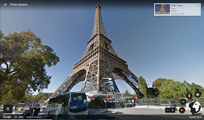
As an art teacher I'm thinking of re-vamping my two-point perspective drawing project so students get to use the street view feature. Students can find a building or location to draw in two-point perspective and use actual real time pictures of the location to draw from. For example if I had a student who loves France, is taking french, and dreams of visiting their one day they can search the Eiffel Tower and draw it for their project. How cool and so personal to that student!
Here is what a great 2 point perspective view of the Eiffel Tower would look like.
The next tool is Google Tour Builder. It is literally what its named. A tool to build tours all around the world. I built this awesome tour of Museums around the Kansas City Area. Check it out!
I'm super proud of this tour I designed and something I think my students would enjoy if they've never been to any art museums in the Kansas City area.
Wanting to know how to build your own tour watch this video!
Check out some features of Google Maps in this video.
Well folks that's all I've got for you this week. Some extremely useful apps and websites for those jet setters or if you just have wanderlust like I do. Take some time to explore them and get the itch to travel. I know I will, is it spring break yet?

Comments
Post a Comment